


Dharhiaro – the name itself has a magical ring about it. It was first brought to my attention in June 1941 by a student belonging to a Dharhiaro tribe, who was returning to his village just below the plateau.
Thirteen years later, Dharhiaro was to enter my life, my thoughts and my work. I came across an article by Dr. Lalor who had camped with British officials in Dharhiaro in 1860. His article published in the Bombay Geographical Society Journal in 1864 revealed that the development of Dharhiaro into a summer hill resort had been under serious consideration by the British authorities in Sindh, since the mid 19th century.
The location given by Dr. Lalor was 27-20 degree North latitude and 67-17 degree Fast longitude. The climatic data indicated that with the provision of water the place could be transformed into a hill station.
The possibility of growing deciduous fruit crops in Dharhiaro was an exiting prospect. I knew that prior to planning anything I had to personally verify the information given in the Sindh Gazetteers (1876 and 1927) and the facts in Dr. Lolar’s article.
Animals.
I also wanted to visit Kute-ji-Kabar, three miles South of Dharhiaro. There were three other peaks, more than 6,500 feet high to be investigated.
I realized that Dharhiaro’s potential as a summer resort could only be ascertained during the last 2 to 3 days of May or the first 2 or 3 days of June, when the temperature would reach the maximum in the plains and so probably also in the hills. Accordingly I camped at Mehar and at 4.00 in the morning of 31st May, 1954 set out for Faridabad 16 miles W.N.W. From here I left for Shah Gadrio 11 miles further in the same direction and reached this place by 6.00 a.m. We had already graded all roads by bulldozers.
Accompanied by Supervisors Messrs Umer Khitab and Kameso Khan and two guides, I left Shah Gadrio for Unnhar Nai 10 miles further W.N.W. and on reaching it headed for Pianro Lak 16 miles further. Approximate 4 miles before Pianro Lak we changed to for our destination, which was at a height of about 3,500 feet. We reached opposite to Pianro Lak at 8 a.m and it took us three hours to cover the last 6 miles to the hill top on crawler tractor. The total distance from Mehar was 59 miles. Enroute, to our surprise, we came across domesticated animals grazing on the slopes of the hills – sheeps, goats, cattle and occasionally, camels. There was growth of pish in almost every depression where rain water could collect for a few days, as well as other bamboo-like plants known by different names: Kahu, Lahirio and Rorhi. Occasionally in some depressions we found acacia or bubble trees.
Tribes.
On the hill slopes, Sindhi Jutt tribes had set up small temporary settlements. They called themselves Baluchi but they spoke neither Baluchi or Brohi languages. They came down from the hills to the plains every winter to find work as labourers and to sell their animals. In 1860, when Dr. Lalor visited them these tribes called themselves Chuttas, a sub-cast of Jutt.
Fauna.
This area had a large number of ibex and gad but uncontrolled killing of these animals led to a dangerous decrease in the species.
Lalor had identified the following species of animals on these hills; ibex, hyena, black bear, wolf, panther, fox and gad (wild sheep). Among the birds he came across were: vullur, goshawk, raven, grey pigeon, red legged partridge and quails. He also encountered reptiles, snakes and iguanos. I collected considerable data from the local people on animals which existed in that area, in the early 50’s.
These were wolves, jakals, badger, fox civer or kasse, hyena, cats of various sizes, leopards, or panther, mongoose, pangolin, different species of bats, hedgehog, mice, shrew, ibex, wild sheep, hare, rodents, and porcupine. Birds are highly seasonal and compiling complete inventory and accurate information on them was difficult. We did not collect any flora.
Height.
The height of Dahrhiaro is probably 6,500 feet, while Kuti-ji-kabar is 6,877 feet. At 11 a.m we reached the top of the hill – a flat, heart shaped plateau, with good soil as a top cover, a few feet deep. We were informed that after every rainfall, it turns lush green. We took a few samples of the soil for examination at the Soil Chemistry Laboratory, Sakrand, where it was categorized as clayey soil with coarse sandy and some loamy material mixed with it.
Soil.
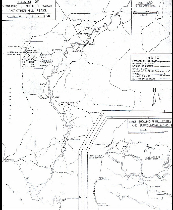
The plateau could be ascended and descended from three or four points along the periphery. There were small settlements on the top where people resided in summer. The area of the plateau acres, and is shown on the map
Lalor had taken a more difficult and longer route from Larkana to Hamal village via Wagan and Warah. From Hamal he followed Mazarani nai to Dharhiaro. Lalor describes a peak called Diana Towers, a name which is unknown locally, unless it refers to Mari Thal and Dablai peaks shown in the map. The presence of ibex and other animals indicated that, at one stage, the hill tops may have been used as watch posts by hunting tribes. There were pools of water along the route and from the hill top some green growth down below was visible. These pools of water were createdby rain water seeping into the rocks which were well fissured and had surfaced at suitable points. These pools however could not be considered a permanent source of water supply.
Climate.
I collected vital data on the temperature which reached its maximum at 74ºF at 2.30 p.m.; came down to 71ºF at 5.30 a.m and at 3.00 a.m it was 65ºF. The humidity was low and varied between 25 to 35 percent in 24 hours. The day was clear with winds blowing from the west. This corroborated Dr. Lalor’s statement. During our 3 day stay, we were lucky not to encounter high velocity winds, though moderate winds were blowing all the time.
Dharhiaro is just on the border of the Mediterranean and the Indian monsoonic climatic zones. The Mediterranean zone experiences rainfall in winters, while in the Indian monsoonic zone of the Punjab and Sindh, rainfalls mostly in summer. Dharhiaro has rainfall in both seasons. The rainfall in the plains just to the east of the hills, as recorded at Mehar, Larkana, Khairpur Nathanshah and Dadu is about 4 inches annually but the hills have greater rainfall, an occasionally in winter too. The frequency of heavy rainfalls in the hilly areas of Sindh as compared to the plains has now been proved statistically. From the information available locally, I concluded that there is usually some rainfall every summer and winter, which helps to sustain vegetation on even high altitudes. This also accounts for the presence of ibex, gad and other wild life. The winters usually become very severe and nomadic tribes come down the hills to the plains of Larkana and Dadu districts. They spend 4 to 5 months there, taking up work like harvesting and threshing of rice and leveling of land, etc.
Plan to Develop Dharhiaro.
I left Dharhiaro at about 4.00 in the morning of 2nd May 1954 to reach the foot of the hills at about 8.30 and jeeped down to Mehar, where the temperature was 118 degree F at 3.00 p.m under shade. In 1954 I concluded that Dharhiaro could only be made a hill station if Sukkur and Kotri were to be connected by a pacca road along the present Larkana, Nasirabad, Mehar Dadu, Sehwan, Kotri road. A pacca road had to be built to Faridabad and from there to Shah Godrio. Now these roads have been built.
I found the task of convincing the Government to open the place as a hill resort a very difficult one, so I decided to initiate a plan for a decided to initiate a plan for a deciduous research station in the hills. The Director of Agriculture at that time was Dr. A.M. Shaikh, who had heard of my trip to this difficult area prior to our meeting. In fact he was of the opinion that “this rash, irresponsible, adventurous and careless boy will kill himself and waste time on fruitless search.”
When I met him he was furious “With whose permission did you go to the top of the isolated hills in a jeep? This is sheer madness. How can anybody justify and account for your trip? If you were looking for ground water, you have 20,000 square miles of the Indus plains in Sindh. It took five years to arrange a scholarship for you to train you abroad and to recruit you as an Agriculture Engineer in Sindh. We will need five more years to replace you if you kill yourself.” I interrupted by saying “I did not travel by jeep to the top of the hill, but rather on crawler tractor”. He was angrier. “If you do not wear a solar hat you could die of sun stroke in the barren hills, where the temperature often goes up to 170ºF in the open area. How could you used government tractor for transport? You needed prior permission.”
I then put Dr. Lalor’s two articles (1860-1864), Gazetteers of Hughes (1876) and Smythe (1919), on his table and informed him that the British were planning to build a hill station in 1919 and were of the opinion that in the absence of proper roads, aviation could simplify the problem, I told him of the possibility of having a deciduous research station in the hills. He had great foresight and immediately began to show keen interest in the project. I informed him that the altitude was 6,500 to 7,000 feet and that the soil was also good. He was enthusiastic enough to promise to pursue the Government for sanction for an experimental farm.
We prepared a proposal for the purchase of a drilling rig for the investigation and development of ground water.
While funds were being arranged for in the last quarter of 1954. Mr. M.A. Khuhro became the Chief Minister of Sindh. Dr. Shaikh asked me to explain the whole scheme to Mr. Khuhro who, I soon discovered, was always too busy. I therefore, decided to approach him just before sunrise, while he was strolling on the lawns of his house. As a result, the scheme for the purchase of power drilling rig was not only sanctioned overnight but due to his personal efforts, orders were placed for the drilling rig by the Central Government within next 5 to 6 weeks. I was sent to Belgium for training on this machine.
While all of us involved in the scheme felt elated at the encouragement received, and the progress achieved, our search for a hill station was far from over. By the time, the rig arrived, West Pakistan provinces had been merged into One Unit and the deciduous research station in Sindh suddenly became unacceptable, as it was believed that Baluchistan and NWFP had more promising areas.
Water.
I met Mr. Khuhro again in August 1958, when he was Defence Minister and on enquiry told him that the drilling rig was available but the scheme had not been approved due to other priorities of the West Pakistan Government. He was also president of the Anti-One-Unit-Front. He promised to arrange for an army helicopter for me to get aerial views of Dharhiaro, Kute-ji-Kabar and other hills peaks in order to prepare a plan for the future Government of Sindh. However, Martial Law was soon proclaimed in Pakistan and the helicopter could not be arranged for the trip. Consequently, we had to drop the scheme.
During this period I was able to check the area with the help of aerial photographs and found that, though there could be a permanent source of water along the nai Gaj running 8-10 miles in Baluchistan, the terrain would be difficult to negotiate. It would probably be easier, cheaper and more reliable if water could be pumped from Warah Branch to the foot of the hills to be repumped to the top of the hills. As an alternative, Hamal Lake could be made a permanent reservoir for the supply of water not only to the hill station but also the surrounding areas. Hamal can have a capacity of 1.2 million acres feet, and if that water could be obtained from the river sources, it would be more economical and feasible. Water could then be utilized for irrigation and the cost of water supply to the hill station would therefore be reduced considerably. Hamal could also be supplied water from three nais, namely Mazarani, Unnahar and Sita. Of these Mazrani drains the area around Dharhiaro. An alternative was to develop ground water, but it would be limited and would get exhausted soon.
Plateau.
There are a total of five peaks in the area, two in Dadu and three in Larkana districts whose heights are over 6,500 feet. Kuti-ji-Kabar is 6,877 feet. Mari Thal West of Mehar, 7,912 feet and Dablai, west of Faridabad 6,527 feet. There is another hill 5 miles to the north of Dharhiaro, which has a plateau at 6,718 feet elevation. Half of this plateau is in Sindh and the other half in Baluchistan. All five peaks are on the Sindh-Baluchistan border. The first four are on the Sindh side of the border. Presently there is a pacca road upto Faridabad, which can also help solve the communication problem. The plateau of Dharhiaro could easily accommodate the landing strip. At places it is about two miles long and one and half miles wide. There is another plateau about 20% the area of Dharhiaro to its north, separated by a small gorge. It is narrow and long and suitable for an air strip. The two could easily be connected. I was told by the people that the hill to the south, a distance of about five miles, was Kuti-ji-Kabar, but I was never able to visit that plateau.
Even today I believe that the hills could be developed. In a few years to come the Right Bank Out-fall Drain carrying 5,000 cusecs of water will flow near Shah-Godrio. This water will be fresh from mid June to end October. It would most probably be utilized for fodder crops in Kachho including the area between Shah Godhrio and Pianro Lak. Hamal will also be developed as a reservoir.
It is regrettable that the conversion of Dharhiaro into a summer hill resort which was believed to be feasible as way back as the early 20th century is today not even under active consideration. The cool beautiful hills of Dharhiaro await development and streams of visitors from the plains of Sindh. But apathy and ignorance are difficult barriers to cross.
By
M. H. Panhwar
A VISIT TO DHARHIARO HILL PEAK IN SEARCH OF A SUMMER HILL RESORT IN SINDH

| Tribute |
| Resting Place |
| Books |
| Articles on Sindh |
| Technical Atricles |
| Activities |
| Photo Gallery |
| Videos |